
Just over a century ago, in 1915, a young German scientist named Alfred Wegener, published his theory of continental drift in Die Entstehung der Kontinente und Ozeane (in German, The Origin of Continents and Oceans). This theory stemmed from a simple, but astonishing observation of a world map: the coastlines of South America and Africa seemed to fit together like the pieces of a puzzle. To Wegener, this suggested that the continents had once been part of one supercontinent, but had somehow broken and drifted apart. Motivated by this observation, Wegener went digging for more information. Luckily for him, it didn't take long before he found fossil, rock, and climate data that also supported his idea of a supercontinent. After putting all this information together, he formally developed his theory of continental drift. Unfortunately, Wegener couldn't explain how continents moved, so he wasn't taken seriously by the geologists of his time. He died never knowing that his theory was eventually accepted and supported (explained) by the theory of plate tectonics. Now that we know a little more about Wegener and his theory, let's look through the evidence that both supports and explains his theory of continental drift.
For a preview of the evidence, and more information about Wegener, watch the video below before moving forward.
What Evidence supports Wegener's Theory?
If you were given the following diagram of our continents and fossil information (below the image), and then asked to explain it, what would you say? How would you rearrange the continents?
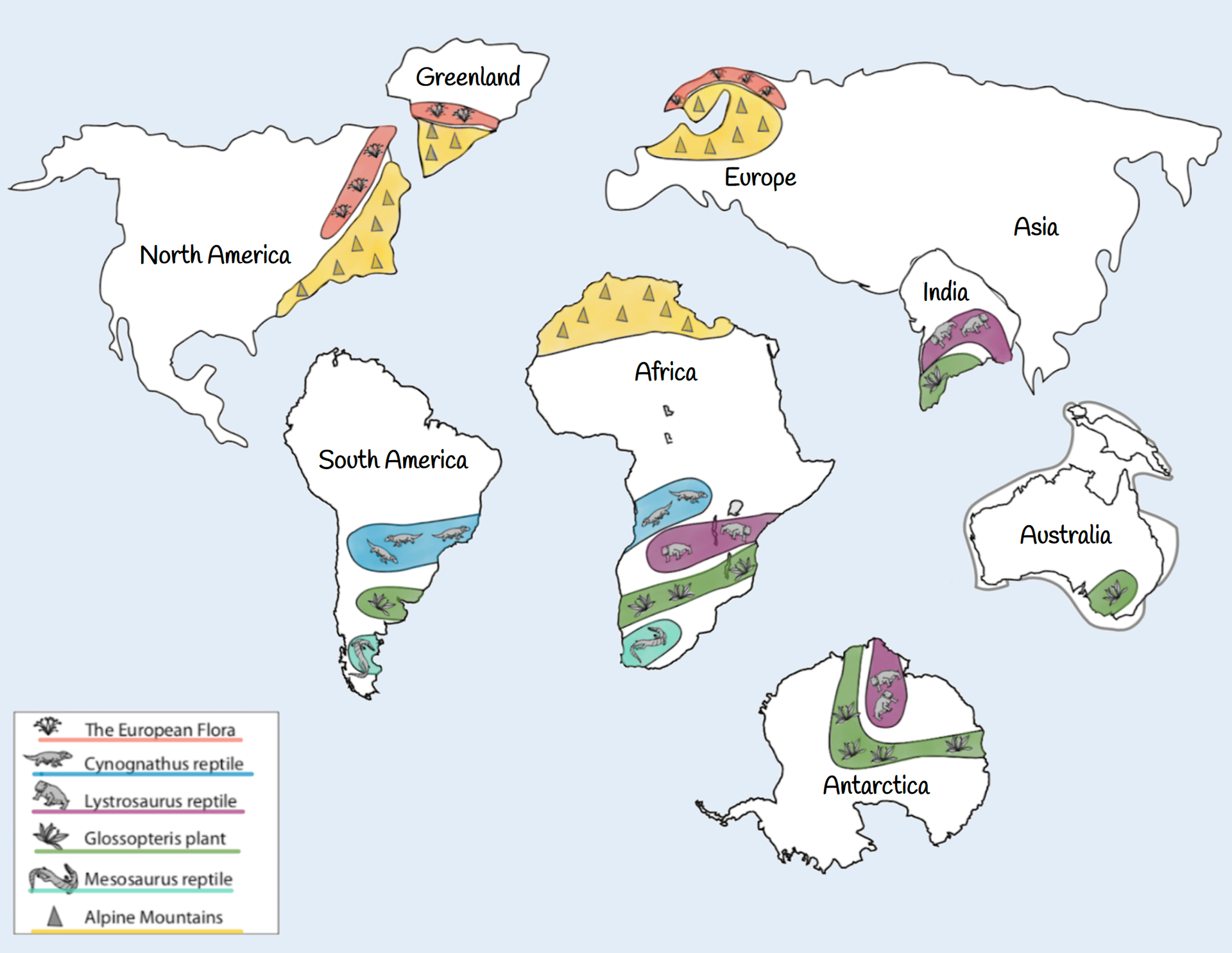
Plant Fossils
The European flora (pink) is a group of plants that lived about 300 million years ago (MYA).
The Glossopteris plant (green) was a fern-like plant with large, heavy seeds that wouldn't have been carried far by wind or water.
Animal Fossils
The Cynognathus reptile (blue) lived about 230 MYA, and was approximately 10 feet long (3 meters). It was a weak swimmer that lived primarily on land.
The Lystrosaurus reptile (purple) lived around the same time as the Cynognathus, and were also poor swimmers who lived on land.
The Mesosaurus reptile (blue-green) lived about 250 MYA. This reptile was about 1.5 feet long (0.5 meters) and lived on both land and in fresh-water (rivers and lakes).
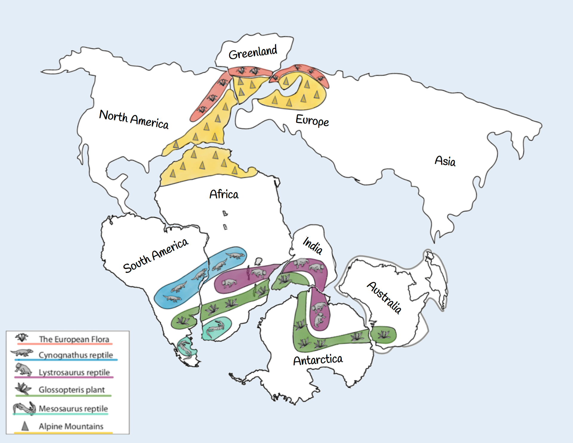
Piecing the Evidence Together
Hopefully, you would be able to use the fossil evidence along with the continent's shapes, and the Alpine mountain range to piece the continents together as shown below.
Not only were the plants and animals unable to cross entire oceans, they wouldn't have been able to survive in such drastically different environments. If you study plants and animals around the world, you will notice that they are each well adapted for specific habitats and climates. Consequently, you don't find the same plants and animals living in Antarctica (a frozen ice ball) as you do in Africa (a tropical continent with lush rainforests and deserts). Therefore, the continents must have once been connected as one giant continent.
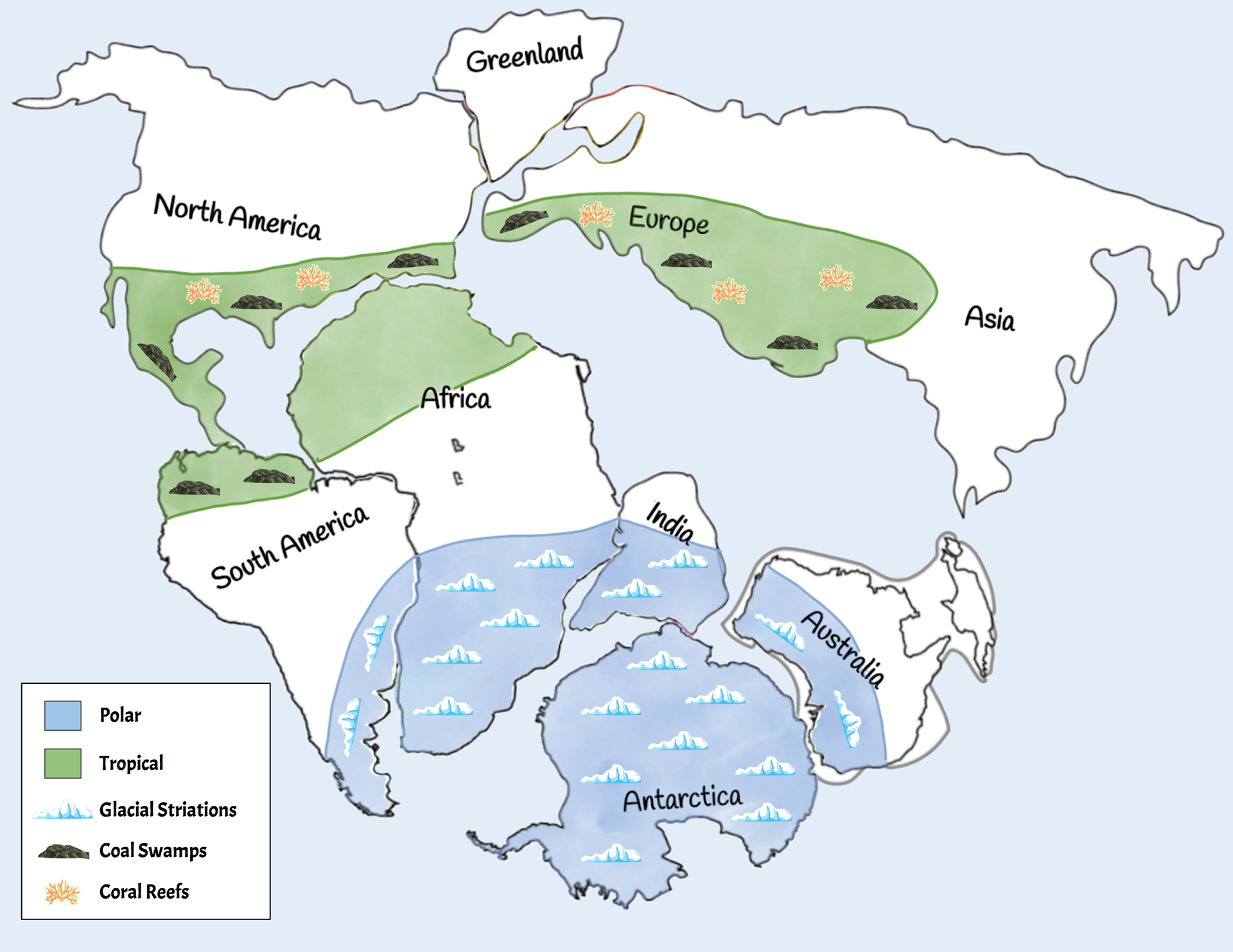
That's not all though. Both climate evidence and rock strata (shown below) suggest the same arrangement!
Climate Evidence
Large sections of South America, Africa, India, Australia, and Antarctica all have similar glacial striation patterns left in the rock. In order for this to happen, the contents we have today must have once been joined together close to the poles (as opposed to near the equator where some of them are now). Similarly, sections of North America, South America, Africa, Europe, and Asia show evidence that they were once tropical environments (i.e., near the equator). A strong piece of evidence for this is the discovery of coal swamps, which form in warm, tropical areas that are teaming with plant life. Additional discoveries of coral reefs and salt deposits suggest the same.
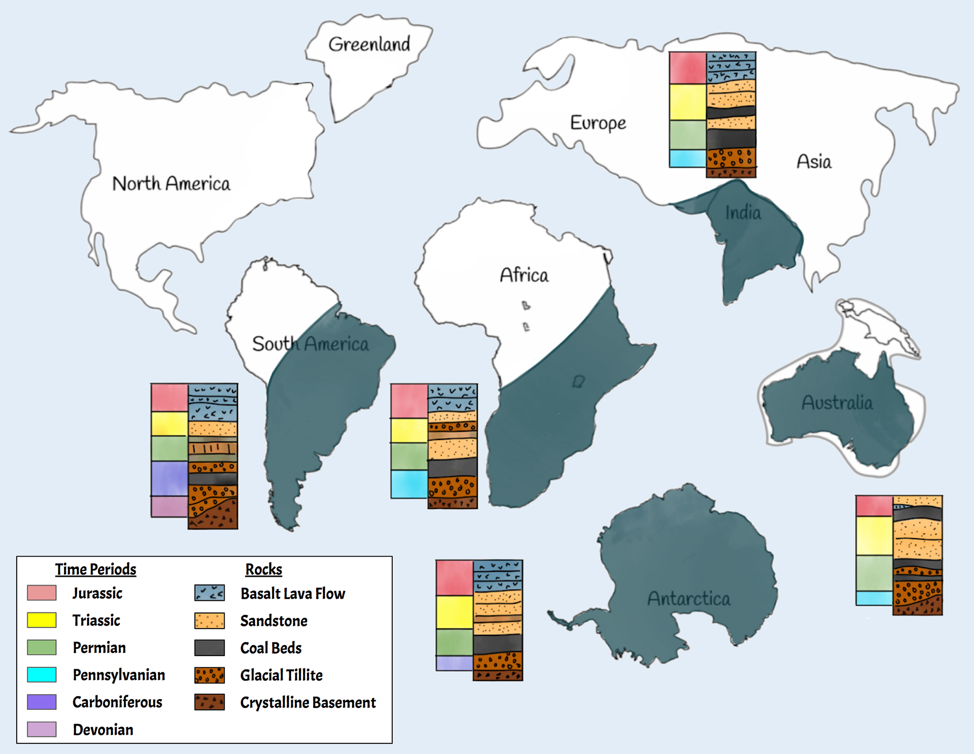
Rock Strata
Large sections of South America, Africa, India, Australia, and Antarctica all have similar rock strata (layers of rock). Since the types and depths of rock strata are determined by environmental conditions, it's not plausible for these areas (which have very different environments today) to have formed the same layers; unless, of course, they were once part of a supercontinent experiencing the same environmental conditions.
How do Continents move?
Wegener thought the continents might have been drifting slowly through the ocean, similar to the way a boat drifts in a current. However, scientist now know that to be false. Instead, Earth's surface is broken into tectonic plates that get pushed and pulled around by convection in Earth's mantle. Watch one or both of the videos below for an overview of how this works.
Identifying Tectonic Plates
The diagram below is showing Earth's tectonic plates. These plates have been identified using several pieces of evidence, as described below the image.
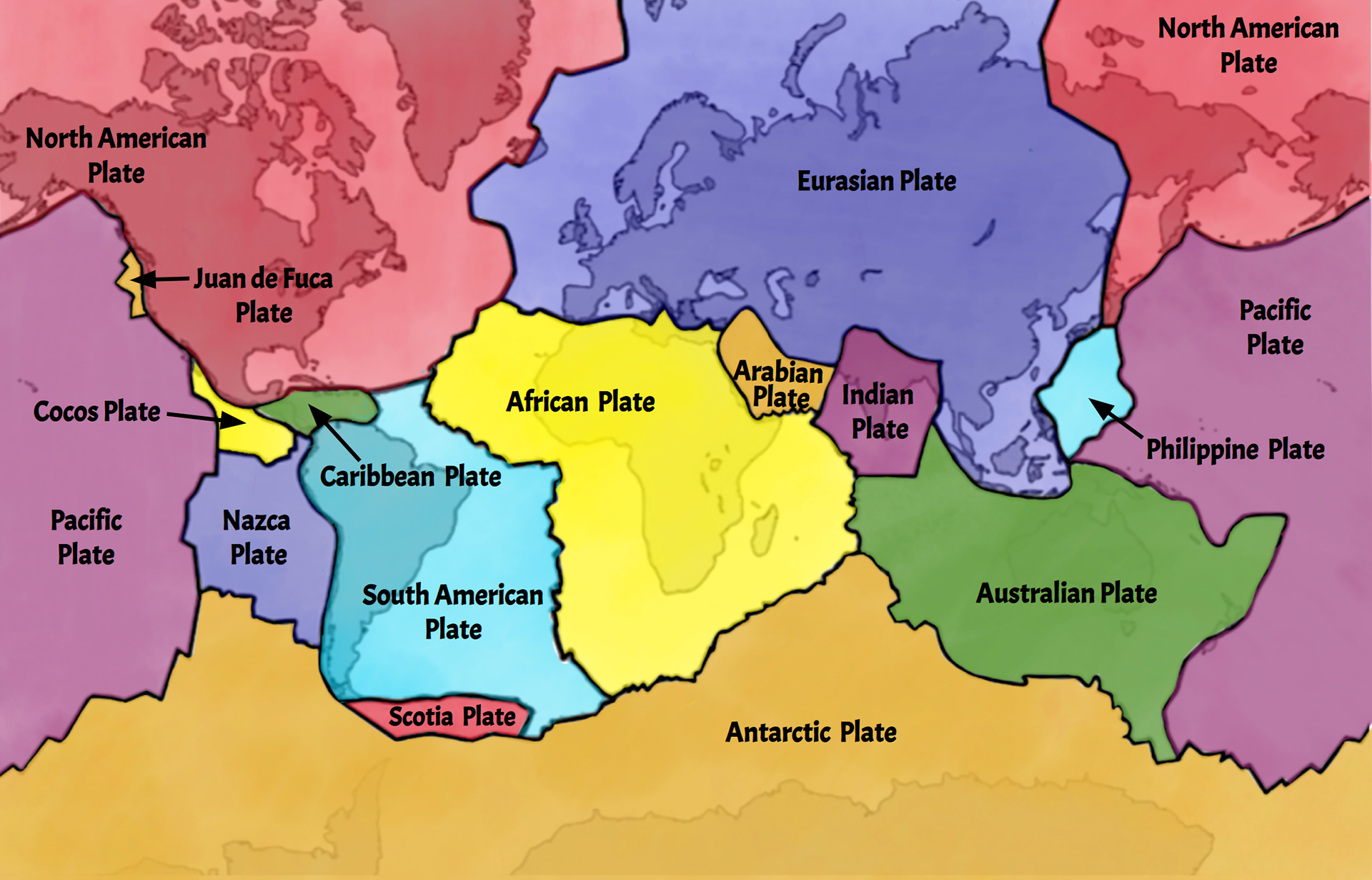
1. Patterns in catastrophic events (namely earthquakes and volcanoes). See these patterns for yourself using the Tectonic Plates, Earthquakes, and Volcanoes interactive by PBS.
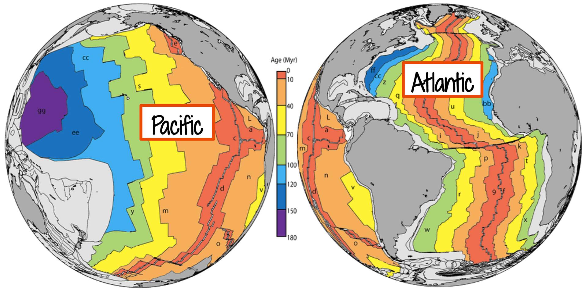
2. The ages of rock in the Pacific and Atlantic oceans that show new rock being formed and pushed outwards at divergent plate boundaries (boundaries that are moving away from each other). See the diagram below for reference.
3. Various landforms that result from the collision or separation of plates. For example, the Himalayan mountain range grows every year as the two plates collide and push into one another. Likewise, the Red Sea and Icelandic Rift are continually getting wider as the plates move away from one another. Did you know, you can actually swim between the tectonic plates in Iceland? Watch a video of it here!
Tectonic Plate Boundaries & Movement
To learn how plates move, use one or more of the resources below.
Challenges/Extensions
Choose at least one of the following activities to demonstrate what you learned!
1. Print, color, and cut out the Global Puzzle, then make your own stop-motion video showing how the continents have moved throughout Earth's history. See the example of a stop-motion video below to help you get started.
2. Learn the "Tectonic Shuffle" (or come up with your own) and create a TikTok or video of it. See the example videos below to get started.
3. Complete this Plate Tectonics crossword.
4. Model tectonic plate movement via convection with this hot chocolate lab!
5. Make a pop-up card of Earth's Layers. See the video below for instructions.
6. Make your own geology treats. Use the links and images below for inspiration, but feel free to get creative with your own designs! You could even search for more geology treats to make!
a.) Edible Tectonic Plates (don't forget to label them!)
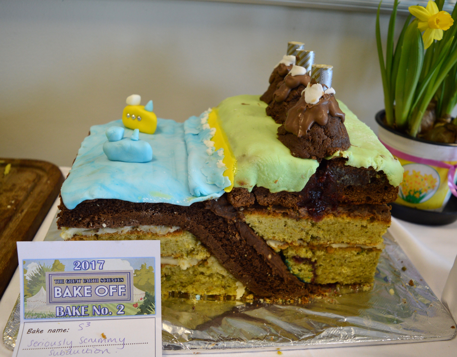
c.) Subduction Zone Cake (as seen here and below via Erin Scott)
Tectonic Plates Cake

Sugar Cookies

Rice Krispies Treat
Subduction Zone
7. Make a labeled model of Earth's layers, tectonic plate boundaries, OR Earth's changing continents over time. Get creative with the model you make. Your model may be one of the following, but feel free to get creative; there are a lot of neat models online you can get inspiration from!
a.) A clearly labeled and colored diagram.
b.) A lego model
8. Take a Plate Tectonics Quiz from Khan Academy.